The Ohio Supreme Court heard a second round of arguments about gerrymandering in less than a month.
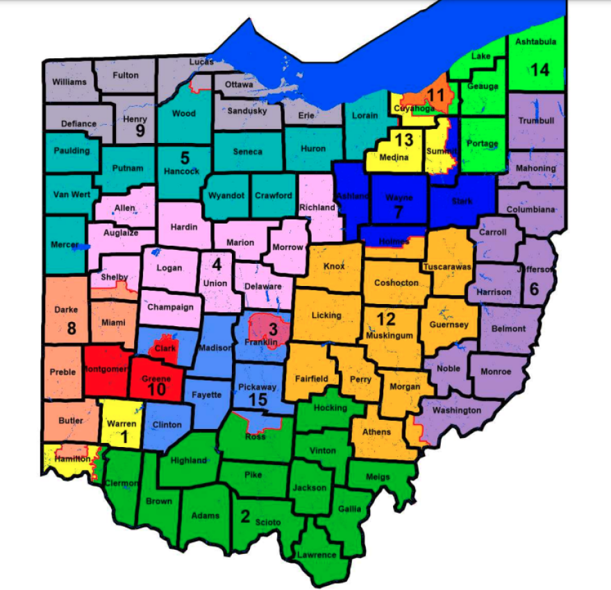
They’re being asked to decide if the state’s new Congressional district map is unconstitutional, by some of the same groups that have also sued over the new maps for Ohio’s state House and Senate districts.
Chief Justice Maureen O’Connor started by welcoming attorneys and online viewers to the arguments on two cases challenging the Ohio Congressional map approved by the Ohio Redistricting Commission and then on a party line vote by Republican state lawmakers last month.
The Ohio Supreme Court has been in person since September, but these cases were suddenly added to the docket between Christmas and New Year’s.
Arguing for a group of voters representing Democratic former US Attorney General Eric Holder's National Redistricting Action Fund and for the League of Women Voters of Ohio was Ben Stafford from the Elias Group, which has challenged Republican-drawn maps in several states. Those groups were involved in lawsuits over Ohio’s state legislative maps too.
Stafford said expert analysis shows Republicans could win 12 of 15 districts in this new Congressional map, in violation of a 2018 voter approved constitutional amendment to end the partisan process for drawing congressional districts.
“This case is about how the General Assembly has thumbed its nose at these reforms and enacted a plan that palpably violates Article 19’s new anti-gerrymandering protections," Stafford told the court.
Stafford and civil rights lawyer Robert Fram argued that a partisan map wouldn’t have resulted in just using Ohio’s geography to create the plan. Fram said the 80% Republican-20% Democratic result was only achieved through county splits.
“When we see a substantial deviation from compactness that results in a substantial increase in partisan gain, that’s a tipoff that what we have here is an unduly partisan, favoring one political party," Fram said.
Earlier this month the court removed from the lawsuits the Democrats on the Redistricting Commission, Sen. Vernon Sykes and House Minority Leader Emilia Sykes, and also Republican members Auditor Keith Faber and Gov. Mike DeWine, who’s incidentally the father of Justice Pat DeWine. That left Secretary of State Frank LaRose, Senate President Matt Huffman and Speaker Bob Cupp, all Republicans.
Arguing for the map they approved was Phillip Strach, a North Carolina lawyer who said map drawing can use partisanship, just not excessively.
"This case is about a Congressional district plan that fully complies with Article 19 of the state Constitution and was the most constitutionally compliant of all the plans before the General Assembly," Strach said.
Strach said the other side’s analysis is deeply flawed because of human interference, and that just using geography would also have created a Republican map.
He reiterated Republicans’ leaders claims that this map has six GOP and two Democratic seats with seven competitive districts, and only splits 12 counties – just over half the number allowed – and two counties, Hamilton and Summit, twice.
Democratic Justice Melody Stewart asked him about that: “It’s almost like you’re saying it’s not as gerrymandered as it could have been.”
“Your Honor, I’m just saying that the Constitution allows five counties to be split twice, so the General Assembly could legally have done that," Strach replied.
Ohio has had a Congressional delegation of 12 Republicans and 4 Democrats since the current map was first used in 2012.
Republican Chief Justice Maureen O’Connor is considered a swing vote since she sided with the minority to throw out the current map in 2011. She asked Strach why he kept comparing the new map to the current one, which is considered one of the most gerrymandered maps in the country and arguably sparked the 2018 vote to change the process.
“If you do compare it to that plan, which has been criticized but was never overruled, that if you look at that plan, it’s clearly –" Strach began his answer.
O'Connor interrupted: "Counsel, didn’t the people overrule it? I mean, maybe not ‘overruled’ in front of us or another court, but the people in their vote overruled what had been done to that point, did they not?"
Strach restated his argument that this new map has more competitive districts and is therefore less partisan, which is what voters wanted, and also said lawmakers didn’t have other maps that would be better.
In his follow up, Stafford said this new map is more gerrymandered than that 2011 one. And he closed with an analogy that might be understandable but perhaps difficult just weeks after OSU lost the Big Game.
“If Ohio State every year has to spot Michigan a two touchdown lead, it might make the game more competitive. The rules are set up to favor one team over the other, and that’s exactly what they’ve done here with their supposedly competitive districts," Stafford said.
The law that created the new Congressional map sets a March 4 filing deadline for candidates for a May primary. Secretary of State LaRose filed a brief that didn’t defend the map’s constitutionality but asked for a quick ruling.
Decisions on this map and on the state House and Senate maps argued before the court a few weeks ago are expected soon.


